


Our value proposition
Delivering tailored research survey expertise and innovative geospatial services
Empowering our clients to uncover market insights and seize opportunities with us!

Invaluable insight for strategic decision making
Specialised research survey and geospatial solutions for diverse industries in South Africa
Let us unlock your market potential!

KasiSurveys & Circle Point Analysis
Understanding socio-economic trends in South Africa
Rapid access to data on townships in South Africa from nationally representative household surveys

Unveiling strategic insights through research surveys
Navigating South Africa’s frontiers with our specialised research survey solution, transforming data into decisions
Get started with our survey services today

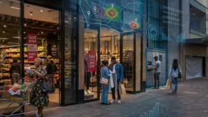
Unleash our geospatial expertise
Elevate strategic insights and decision making with our advanced geospatial data and services
Explore our solutions now!


testimonials
![]()
Development Bank of Southern Africa (DBSA)
“defining geospatial criteria and identifying core datasets in South Africa, delivering a comprehensive report to the Development Bank of Southern Africa (DBSA).”

World Bank
“successfully conducted the 2020 World Bank Enterprise Survey in South Africa, delivering high-quality data from over 1 000 establishments and impressing the World Bank Group with their performance.”
![]()
Government Employees Pension Fund (GEPF)
“exceeded expectations in implementing the GEPF’s Stakeholder Perception and Behavioural Study, delivering an exceptional end product that fully satisfied the requirements of the project.”
Our Innovative Solutions
Geospatial Services
Offering advanced geospatial solutions from
- Database development using machine learning and geocoding
- Map production
- Geospatial analysis
- Retail and government network optimization
- Data dissemination via web mapping
Research Surveys
Innovative research surveys focusing on:
- Consumer financial access
- Micro, small and medium enterprises
- Customer, staff and styled satisfaction
- Business innovation
- Enterprise development
- Retail consumer intercepts
- Government audits
- Surveys
- Opinion surveys
All designed to provide accurate data for informed decision making
Explore MoreOur Unique Expertise
]

Our team demonstrates exceptional proficiency in delivering distinct and inventive geospatial services and research server expertise across South Africa.
The track record of GeoScope underscores its dedication to excellence in catering to industry leaders and facilitating informed decision making in South Africa
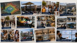
Our Map Viewers
Geoscope – where location meets insight!

Demographic Estimates
Latest demographic estimates of the South African population

Shopping Malls
Shopping malls of different types have been mapped across South Africa

Crime Statistics
Latest crime statistics at a police station level

Retail Census
Access data on 150 000 formal and informal FMCG retail outlets

Township Opportunity Atlas
Access to data on African, Coloured & Indian townships
Our Geospatial Data
Specialist in the development & provision of geospatial data
Demographic Estimates

Total population by age, gender & population group for 2022
Living Standard Measures (LSM)

LSM and SEM data at various levels for 2021
Income

Individual and household income for 2021
Shopping Malls

2022 Shopping mall locations with their trade areas
geoMAPS Consumer

2022 Consumer purchasing behaviour data
Township Opportunity Atlas

Socio-economic data for all townships mapped in 2022
Retail outlets

Retail & FMCG outlets from a national census
Media Coverage

Coverage of print and radio media
Crime statistics

2022 Crime statistics at a police station level
Specialist Geospatial Data

Specialists in developing all geospatial data
Our Case Studies
Helping our clients make more strategic decisions about their businesses
Levi’s
Hungry Lion
McDonald’s

HSRC Business Innovation Survey

World Bank Enterprise Survey
Our Valued Clients
Where our clients see opportunity, we map the way!
