

Information – The Hidden Ingredient of Sustainability
When most people think of sustainable development, images of clean energy, biodiversity conservation, or social justice come to mind. Yet, beneath all these efforts lies something less visible but equally essential: information. Without accurate, reliable, and accessible information, neither governments nor communities can plan, monitor, or achieve the balance between economic growth, social well-being, and environmental protection.
Agenda 21—the landmark global plan for sustainability—was clear about this three decades ago: information is the glue that integrates environment and development. From population trends and poverty levels to land use data and resource consumption, decision-makers need solid evidence to act wisely. Building on Agenda 21, the United Nations’ Sustainable Development Goals (SDGs), adopted in 2015, renewed and expanded this vision for a rapidly changing world. The 17 SDGs—ranging from poverty eradication and quality education to climate action and sustainable cities—place even greater emphasis on data-driven decision-making as the backbone of progress.
Like Agenda 21, the SDGs stress that without reliable information on issues such as poverty levels, land use, resource consumption, and inequality, governments cannot design effective policies or monitor their impact. What has shifted, however, is the urgency: the SDGs set time-bound targets for 2030, making the need for robust, integrated information systems—and especially geospatial data—more critical than ever to ensure no one is left behind.
From Policy to Practice – The Importance of Information Frameworks
Information alone is not enough. It must be organized within a framework that ensures data collection, analysis, and use are systematic and purposeful. Globally, models such as the Driving Force-State-Response (DSR) and its variations (e.g., DPSIR) have guided countries in building sustainability indicators. These frameworks connect human activities (driving forces) to environmental and social outcomes (state) and then to government actions (responses).
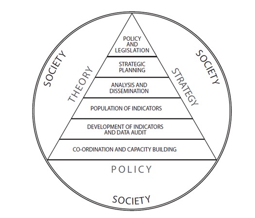
This framework presents a structured model for managing information systems that support sustainable development, emphasizing that data must be integrated with policy, theory, strategy, and society. The pyramid illustrates a progression from foundational co-ordination and capacity building, to the development and population of indicators, followed by analysis and dissemination that turns data into usable insights. At higher levels, it supports strategic planning and culminates in policy and legislation, where information informs governance and decision-making. Encircled by the broader dimensions of society, theory, strategy, and policy, the framework highlights that effective sustainable development depends on an integrated information ecosystem where capacity, indicators, analysis, and governance function cohesively.
As an example, the Department of Environmental Affairs in South Africa has already developed over 120 indicators. But challenges remain: while environmental data is fairly advanced, social and economic indicators are often fragmented, hard to access, or inconsistent at local levels. This gap highlights the importance of coordinated well-funded systems that cut across sectors and geographies.
Africa’s Challenge – Bridging the Information Divide
The African continent faces unique obstacles. Many countries struggle with limited institutional capacity, outdated census data, and scarce resources to maintain comprehensive information systems. Initiatives like the Africa Environmental Information Network and NEPAD’s development agenda stress the need for reliable data to track poverty reduction, health outcomes, and environmental resilience.
In recent years, Africa has launched several initiatives to overcome its chronic information challenges—limited institutional capacity, outdated census data, and fragmented systems—by strengthening data governance, infrastructure, and statistical modernization. Efforts include the Africa CDC’s health data governance framework, the Pan-African Parliament’s push for FAIR data standards, and the UNECA Transformation Roadmap (2023–2030) to digitize and modernize official statistics. Complementing these are the Africa Data Leadership Initiative (peer-learning for policymakers and technologists), regional programs like the Eastern Africa Regional Statistics PforR, and major private-public investments such as the World Bank–IFC’s $100 million Raxio data-center expansion. Together, these efforts are building resilient, integrated, and future-ready information ecosystems to track progress on poverty, health, environment, and development goals across the continent.
Without this foundation, ambitious goals such as halving extreme poverty or achieving universal education (by 2015 as originally set under NEPAD) remain out of reach. Effective action requires governments, research institutions, and international partners to invest in data infrastructures—from household surveys and monitoring systems to Geographic Information Systems (GIS).
Among all forms of data, geospatial information stands out as a game-changer. By linking statistics to geography, GIS allows us to visualize inequality, map environmental degradation, or model access to services like schools and healthcare. For instance, mapping the Gini coefficient at municipal level in South Africa provides a striking view of income inequality across regions. Geospatial data also enables “what if” scenarios. Policymakers can test how building a new dam would expand water access, or how rapid urbanization could affect land use. This capacity to simulate futures makes geospatial information indispensable for proactive, evidence-based decision-making.
Sustainable development is not just about planting trees or reducing emissions. It’s about making informed choices today that safeguard tomorrow. For South Africa and the African continent, the journey involves:
- Strengthening institutional capacity to collect and analyse data.
- Ensuring that social, economic, and environmental indicators are updated regularly.
- Making information accessible to decision-makers and the public in usable formats.
- Investing in GIS and other technologies that transform raw data into actionable insights.
Ultimately, achieving sustainable development depends on more than ideals—it depends on building a robust information framework that connects knowledge with action. Without it, sustainability risks becoming little more than a slogan.
From Data to Insight – GeoScope’s Geospatial Intelligence
Building on the critical role of information in guiding sustainable development, GeoScope amplifies this by transforming raw geospatial data into strategic insights that empower both the private and public sectors. Their geospatial services span the development of proprietary datasets via machine learning and geocoding, map production, geospatial analysis, and real-time fieldwork tracking using geofencing technologies. A standout feature is their use of Circle Point Analysis (CPA) – a dynamic mapping method that displays survey responses by geographic location, enabling clear visualization of socio-economic patterns across townships – often presented via their “KasiSurveys” tool. By combining small-area estimation techniques, GeoScope models vital indicators like LSM, income, and unemployment at fine geospatial scales, making localized decision-making more informed than ever.
Case in Point: McDonald’s Network Expansion
A practical illustration of GeoScope’s geospatial expertise is its work optimizing McDonald’s restaurant network in South Africa. By applying accessibility modelling – balancing demand, consumer behaviour, transport logistics, and geospatial data – they helped define the ideal number and locations of restaurants. This enabled McDonald’s to expand strategically while minimizing overlap and ensuring optimal market reach – an excellent example of how geospatial analysis can improve business outcomes and urban accessibility.
Deepening Understanding through Survey Design – GeoScope’s Research Excellence
On the research front, GeoScope (anchored by AfricaScope’s broader capabilities) brings methodological rigour and innovation to surveys and data collection. Their services encompass all stages – from questionnaire and sample design to fieldwork planning using maps, real-time tracking, and robust quality control, through to analysis and reporting that integrates geospatial techniques for executive decision-making. By collaborating with financial institutions and governmental bodies, they deliver invaluable insights into economic development, customer satisfaction, and stakeholder perceptions across South Africa and beyond.
Case in Point: World Bank Enterprise Survey in South Africa
One notable project is their successful implementation of the World Bank Enterprise Survey in South Africa, where GeoScope was entrusted with the full suite of research tasks, from planning and data collection to ensuring data quality across over 1,000 establishments, with results that impressed the World Bank Group. This exemplifies the seamless fusion of geospatial support and survey expertise – turning beneath-the-surface data into strategic insights that inform policy and economic interventions.
As the world accelerates toward the 2030 Sustainable Development Goals, the call is clear – we cannot achieve what we cannot measure. Africa and South Africa stands at a crossroads where reliable, integrated, and geospatially grounded information systems will determine whether aspirations translate into lasting change. This is where governments, private sector leaders, researchers, and development partners must act boldly – by investing in modern data infrastructures, supporting institutions that generate and analyse high-quality indicators, and embracing innovative geospatial tools like those pioneered by GeoScope and AfricaScope. The future of sustainable development will not be built on good intentions alone, but on evidence that guides action, accountability, and impact – and the time to strengthen that foundation is now.
If you would like us to help you with your information needs, whether it be through the conducting of research surveys or providing geospatial data solutions, contact us now
