


Imagine a world where location isn’t just a coordinate on a map. In this world, every school, clinic, and crime hotspot connects to a living digital ecosystem. Decision-makers scan live data to predict vulnerability hotspots before a crisis even begins.
This isn’t science fiction; it is the dawn of the geo-generalist era – where anybody can access geospatial data by simply posing a question. This was Craig Schwabe declaration at the Data and Evidence GIS Open Day hosted by Western Cape Government in November 2025.
Using geospatial data and AI Agents decision-makers can have the power to trigger targeted interventions based on real-time policy and strategic planning objectives. Using Large Language Models and AI algorithms digital planning assistants can test thousands of spatial scenarios overnight to propose optimal locations for infrastructure.
We are moving toward a future where we can monitor the social welfare journeys of indigent people or school learners or clinic patients through space and time. In a caring world this would ensure that no citizen falls by the wayside – having access to all government social services.
This geo-generalist world provides the intelligence needed for timely development and program implementation.
We are witnessing a time where spatial data will act as a key driver for all societal improvements. Governments and businesses alike must prepare for this reality now to stay relevant.
Key Takeaways
- Geospatial + AI will allow for the testing of thousands of planning scenarios to optimise resource allocation.
- South Africa is institutionalising spatial intelligence through initiatives like the Geospatial Information Management Strategy (GIMS).
- The “Elephant Parable” illustrates how integrating multiple data sources creates the opportunity for a shared, accurate understanding of reality.
- AI enables the integration and analysis of all forms of data, such as satellite imagery and text, to reveal hidden socio-economic patterns.
- Future advancements of the use of AI and geospatial data may see national censuses being something of the past.
An Evolution of Spatial Thinking – From Wetland Mapping to Master Plans
Craig’s journey into the geospatial world began decades ago in the fields of ecology and resource management. In 1987, as a qualified ecologists he used satellite imagery to map the high alpine wetlands in the Drakensberg mountains. It highlighted the distribution and types of wetlands that required protection. This data proved vital for understanding how land use practices were negatively impacted wetlands.
Early GIS projects in my career demonstrated that traditional planning often ignores vital land resources and social aspects. For instance, a resource assessment for the Qadi Tribal Area outside Durban revealed gaps in a master plan created by planners who lacked spatial and social insights. By mapping land suitability for agriculture and infrastructure, a holistic land use plan could be developed. This plan benefited the entire community by integrating multiple layers of information.
These early lessons informed a broader geospatial perspective. Geospatial data should not be used in isolation – instead, integration of all forms of data will ensure that the environment and people’s needs are respected. This foundation ensures that modern spatial intelligence remains grounded in practical reality.

Establishing the Backbone – Legal and Institutional Frameworks
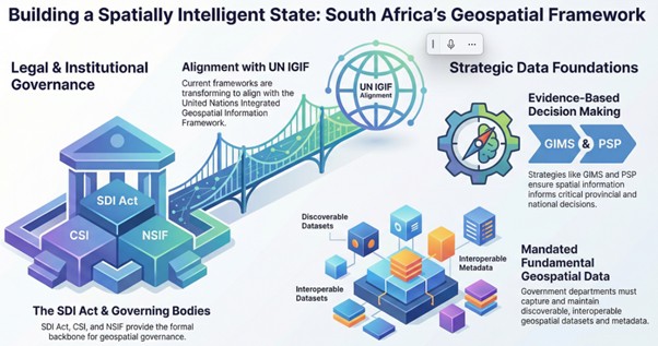
South Africa possesses a strong legal and institutional backbone for geospatial governance. The Spatial Data Infrastructure Act established the Committee for Spatial Information (CSI) to oversee aspects such as data standards. Additionally, the National Spatial Information Framework (NSIF) support to the CSI to maintain its functioning. These structures ensure that data is not just collected but is effectively governed.
Current efforts are now focusing on transforming these frameworks to align with international standards, such as the United Nations Integrated Geospatial Information Framework (UN-IGIF). This will ensure South Africa aligns to the global geospatial ecosystem and ensure that our data management strategies meet international best practices.
The Western Cape province serves as a prime example of evidence-based decision-making. Their provincial strategic plan uses spatial information to guide every major policy shift. By making this commitment to data ensures that the Western Cape government remains transparent and effective.
By identifying fundamental geospatial datasets, the national government ensures that information is discoverable and interoperable. Strategic investment by national and provincial departments remains critical for this to success. The SDI Act and the CSI, mandates departments to capture metadata and maintain their data assets. This creates a data foundation that allows South Africa to become a spatially intelligent state. Without these legal pillars, the geo-generalist vision would remain a dream.
The Power of Strategic Alignment – GIMS and National Development
The launch of the Geospatial Information Management Strategy (GIMS) on September 19, 2025, marked a major turning point. Minister Ramakapa highlighted that the government is now spatializing the national development agenda. This strategy signals that geospatial information is vital for the country’s strategic growth. It requires high-level political support and the commitment of all government departments.
Frameworks like GIMS must link directly into existing legislation and international guidelines. By integrating into the United Nations global strategy, South Africa ensures its processes are world-class. This integration enables the use of geospatial information by both government officials and everyday citizens. It democratizes data for the benefit of the entire society.
A data-driven approach allows for the monitoring of development trends and the anticipation of risks. Leaders use these insights to allocate scarce resources across the country. For example, the Western Cape’s focus advocates the use of spatial technology to enable economic growth, jobs creation and harness innovation to attract exports and investments.
Targeted interventions ensure that infrastructure investments are fit for purpose. When investments are in the right place, they unlock economic activity and attract international investors. This catalysation of growth is essential for South Africa’s economic growth. Spatial intelligence turns a simple investment into a strategic accomplishment.

Social Transformation Through Spatial Intelligence
Geospatial data is a powerful tool for targeting impoverished communities that need support. Within the Cape Peninsula and beyond, it identifies areas where infrastructure investment will have the most impact. Leaders can use it to develop skills and support small-to-medium enterprises in specific zones. Spatial transformation is key to reducing poverty and inequality.
Geospatial technology also plays a crucial role in public safety by identifying crime hotspots. Law enforcement can use this data to guide deployment and protect infrastructure. Communities feel safer when police presence is based on accurate, real-time spatial analysis. It transforms reactive policing into a proactive shield for the public.
Education and health facilities also benefit from using a spatial lens. The most effective locations for primary schools, secondary schools, and clinic can be identified. This improves the overall well-being of citizens by ensuring services are accessible. South Africa must continue to collect this data to maintain a healthy geospatial ecosystem.
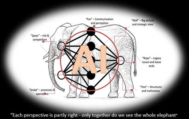
The “Elephant Parable” reminds us that complex social challenges have many sides. If departments only see their own data, they are like blind people feeling one part of an elephant. Each perspective is partly right, but only together do we see the full reality. Geospatial information integrated in AI Agents provides the shared understanding needed to see the full complexity of South African society.
AI Orchestrates the Geospatial Ecosystem
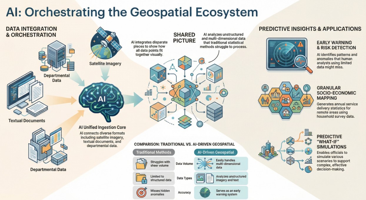
Artificial Intelligence sits at the centre of this new world, orchestrating responses to complex questions. It connects different perspectives while geospatial information provides a critical locational dimension. AI enables the ingestion of data in various formats from multiple departments. It then creates a shared picture showing how all these pieces fit together.
Once the data is integrated, AI identifies patterns and common anomalies. It serves as an early warning system for risks that human analysts using selected data might miss. AI also allows officials to simulate “what-if” scenarios for different audiences. This predictive capability is essential for effective decision-making in a complex world.
Normal statistical methods often struggle with the sheer volume and complexity of multi-dimensional data. AI overcomes these limitations and enables the analyse of all forms of data from unstructured data like satellite imagery to textual documents across the Internet. It extracts invaluable insights that traditional methods simply cannot achieve.
For example, it creates granular, nationally representative data from household surveys on wealth indicators like the Living Standard Measure (LSM) and the Socio Economic Measure (SEM). By applying AI to household surveys, we generate annual statistics on service delivery at a granular level. This is often the only way to provide critical data for development planning in remote areas.
AI makes data collection cost-effective and highly accurate.
The Future – Real-Time Insights
The use of AI and geospatial data is expanding rapidly across the globe. We now have real-time access to data from drones, satellites, and the internet. The use of AI and geospatial technology contributes to instant disaster responses and even daily traffic management. The speed of accessing information allows for a more agile and responsive government.
Perhaps an example of the most disruptive change when integrating AI with geospatial data is the end of traditional national censuses. In the future, spatial analysis using AI and household surveys will estimate population sizes more efficiently. This will do away with the requirement for expensive, time-consuming censuses. We are moving toward a time when continuous, real-time understanding of our population can be achieved.
This is just the beginning of the journey into a geo-generalist world. We are already seeing the application of AI to developing three-dimensional models and temporal modelling. These tools help us visualize urban growth and predict climatic change risks over time. The future of AI and geospatial data is not some distant goal; it is here now.
Every societal problem we face, from urban sprawl to climate change, requires a spatial solution. By embracing AI and geospatial technologies, provinces like the Western Cape and cities like Cape Town can lead the way. The geo-generalist world is one where geospatial data serves the people and ensures a better future for all.
Frequently Asked Questions
How does Artificial Intelligence improve the way we use geospatial data?
AI acts as a central orchestrator that can ingest massive amounts of data from diverse sources and formats. Unlike traditional statistical methods, AI can process large amounts of unstructured data such as satellite imagery, aerial photography, and even text from documents. It reveals hidden patterns and anomalies that provide early warning signs for potential risks. By providing a locational dimension, AI allows decision-makers to simulate “what-if” scenarios, helping them understand the potential impact of their decisions before they are implemented. This makes decision-making more evidence-based and proactive rather than reactive.
Why is the Geospatial Information Management Strategy (GIMS) important for South Africa?
GIMS represents a major turning point because it signifies the “spatialization” of the national development agenda. Launched in late 2025, it provides the strategic framework needed to ensure that geospatial information is used for targeted and timely development. It mandates government departments to capture and maintain high-quality data and metadata, ensuring it is discoverable and interoperable. This strategy moves the country toward becoming a “spatially intelligent state” where resources are allocated based on data-driven insights. It also begins to aligns South Africa with international standards like the UN-IGIF, making our spatial data globally compatible.
Can AI and spatial analysis really replace a national census?
Yes, the future points toward a shift where expensive and labour-intensive national censuses are replaced by more agile AI and machine learning methods. By using AI to analyse satellite imagery and nationally representative household surveys as spatial data, researchers can accurately estimate population sizes and distributions on a more regular basis. This method is more cost-effective and allows for the generation of annual statistics rather than waiting a decade for new census results. As these methods evolve, they will provide a much more dynamic, accurate and granular view of urban growth and population shifts that a traditional census ever could.
